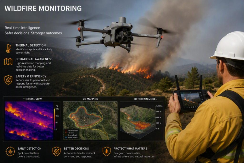
Wildfire Prevention & Detection
Find out more about how we can assist here.
Tailored Drone Solutions
At UAS LUX, we specialize in delivering tailored drone solutions designed to meet the specific needs of each client across diverse industries. Whether it’s precision agriculture, thermal inspections, mapping, or aerial documentation, our approach begins with understanding our clients’ objectives and building a custom flight and data plan to achieve them efficiently. Combining advanced UAS technology with expert analysis, we ensure every project delivers actionable insights, reliable results, and measurable value for your operations.
Thermal Drone Imaging:
UAS LUX provides advanced thermal drone imaging, enabling a range of innovative applications, such as:
- Solar panel inspections (IR & EL)
- Building inspections
- Infrastructure monitoring
- Wildlife / Livestock management
- Search and Rescue
We are equipped to operate in adverse weather conditions.
Drone Photogrammetry:
Photogrammetry, in its simplest terms, is the process by which a large number of photographs are combined into a single very high-definition image. By combining nadir (straight down) and oblique (side) images a 2D map and 3D model of an area can be derived.
Drones are the best tool to efficiently and cost-effectively take hundreds (if not thousands) of photographs at regular intervals, in order to cover an area with ample overlap between photographs for the photogrammetry software.
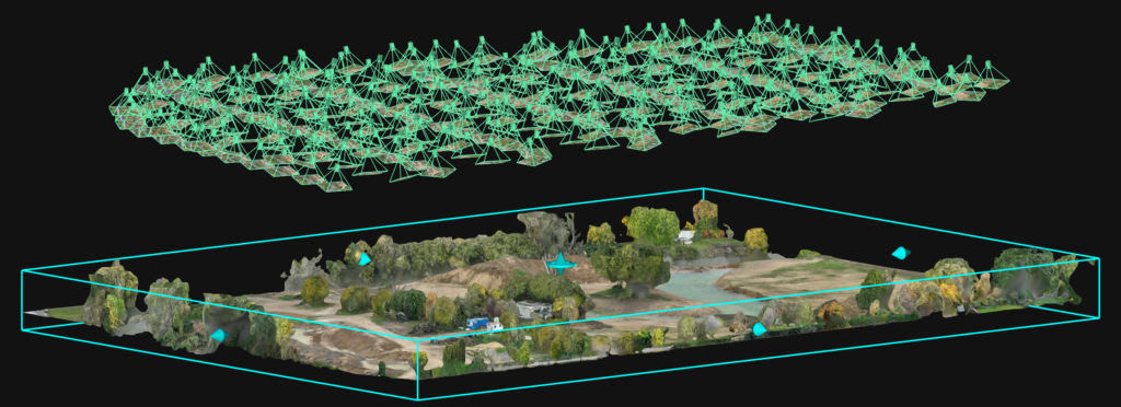
Photogrammetry can then be used to create a simplified digital representation of an area in both 2D and 3D as demonstrated in the video above and below.
Our comprehensive suite of professional drone services caters to a diverse clientele, ranging from commercial developers to utility providers.
Some examples of how Drone Photogrammetry is used in various sectors:
Construction
- Volumetric Analyses
- Site Progress Reports
- Digital Twins (BIM)
- Inventory Management
Property Inspections
- Current State of Object
- Maintenance
- Damage Detection
- Insurance
- Inventory Management
Municipal Services
- Urban Planning
- State of Infrastructure
- Flood Mitigation
- Waste Management
Energy / Telecom Inspections
- Transmission Towers
- Power Lines
- Wind Turbines
- Solar Farms
Infrastructure Inspections
- Roads
- Bridges
- Towers
- Water Infrastructure
Agriculture
- Crop Inspections
- Silo Inspections
- Inventory Management
- Stockpile Measurements
Pilot-for-Hire Services
UAS LUX offers Pilot-for-Hire services for Standard Scenarios 01 & 02